
I judge a boat and RV site by whether customers can use it - not just how close it is to the highway. Before trusting a short drive time, I check the legal towing route, test turns with the largest expected rig, and measure gate queue space.
My review covers:
- Routes: Travel times in both directions, peak-season traffic, and vehicle restrictions.
- Site access: Safe entry, turning room, overhead clearance, and emergency access.
- Nearby stops: Fuel, dump stations, and repair shops that can fit the same rig.
- Costs and risks: Legal access, permits, repair estimates, and effects on rents and occupancy.
I use a 1–5 scorecard backed by dated maps, photos, and measurements. But <u>a good average never cancels out unsafe or blocked access</u>. I separate fixes from approval-dependent work and site limits before setting a repair budget or purchase price.
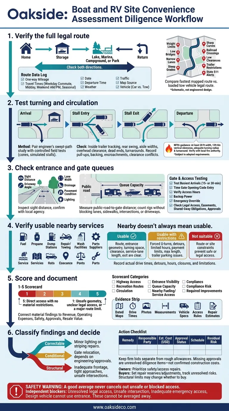
Boat & RV Site Access: From Route Check to Investment Decision
Trace the full trip from home to storage, then to the lake, marina, campground, or park - and back. Map likely customer origins to highway interchanges, major roads, boat ramps, marinas, campgrounds, and national parks where relevant. Check both directions. An easy arrival may hide a difficult left turn or backtracking on departure. Use that full trip as the baseline for every access test that follows.
Measure Drive Times and Check Road Restrictions
Record one-way mileage and travel times during weekday commutes, weekday midday, weekend morning departures, and weekend afternoon returns. Repeat key routes during the local recreation season. Log the date, departure time, weather, traffic, map app or GPS source, and vehicle. Keep passenger-car trips separate from towing trips. Check state 511 alerts for construction, closures, and weather disruptions.
Compare the fastest mapped route with the legal route for the loaded tow vehicle. Check posted weight limits, low bridges, narrow lanes, steep grades, sharp curves, railroad crossings, low clearances, and trailer restrictions against state transportation records. Use the expected vehicle’s loaded dimensions and weight, not passenger-car routing settings. FHWA identifies restricted clearances, bridge weight limits, and inadequate turning radii as barriers that can force detours.
Document Route Findings for Site Review
Use the table below as a recording template, not verified site findings. Replace each instruction with measured observations before using it in underwriting. Include the measurement date and departure time with every drive-time entry. Keep weekday conditions separate from peak recreation conditions.
| Destination | Distance | Typical Drive Time | Route Constraint | Site-Review Impact |
|---|---|---|---|---|
| Highway interchange | Measure usable route miles | Record weekday and weekend times, with dates | Check ramps, left turns, and detours | Define practical highway access |
| Residential trade area | Measure from likely customer origins | Record commute and midday times, with dates | Check local restrictions and backtracking | Define customer targeting and marketing radius |
| Boat ramp or marina | Measure trailer-appropriate route | Record launch and return periods, with dates | Verify narrow roads, bridge limits, and seasonal access | Test boat-customer convenience |
| Campground or national park | Measure legal RV route | Record peak-season times, with dates | Verify grades, closures, and final-mile road conditions | Test RV demand and rental-rate assumptions |
Alongside the route log, document road frontage, entrance visibility from both directions, permitted signage, and any observed queues extending toward the public road. Confirm sign permissions with the local jurisdiction; frontage alone doesn’t guarantee signage rights. Use these findings to adjust directions, gate hours, and customer targeting, and to test whether access supports projected occupancy and rents.
If the route works, next check whether the entrance and circulation area can handle the same vehicle.
Once route access is verified, check whether the largest vehicles can move through the site without conflict. Test arrival, stall entry, stall exit, and departure separately. Use the longest expected RV combination, the largest boat-and-trailer combination, and the required emergency apparatus - not passenger-car parking assumptions.
Getting through the entrance doesn’t mean a vehicle can reach or leave its assigned stall. Record whether each movement takes one continuous turn, requires backing, crosses opposing traffic, or works only when neighboring stalls are empty.
Verify Turning Paths and Clearances
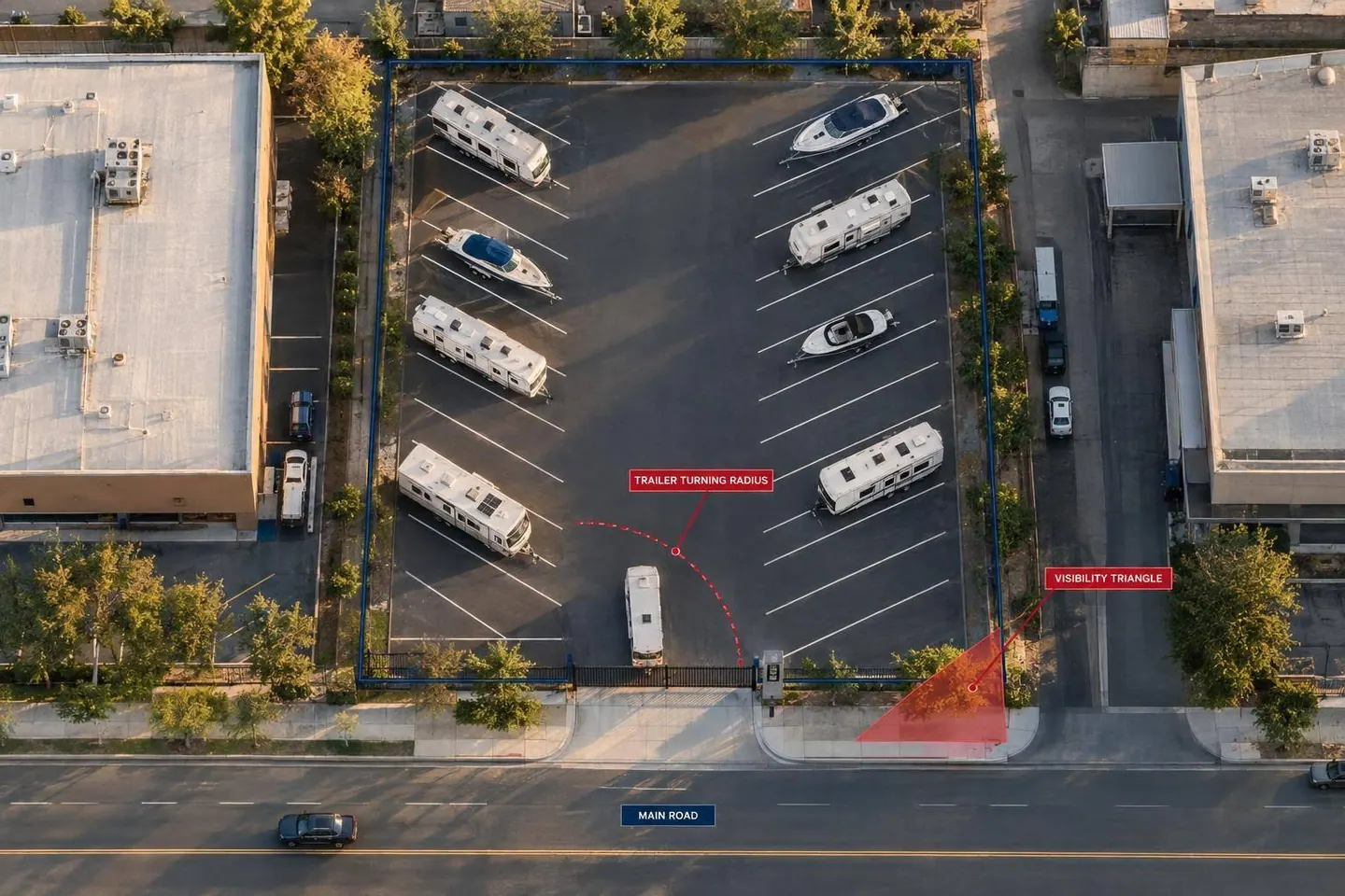
Have a qualified engineer prepare a swept-path study using documented vehicle length, width, height, wheelbase, axle locations, hitch position, articulation points, and rear overhang. Turning radius tells only part of the story. Trailer wheels can track inside the tow vehicle’s path while the rear corner swings toward parked units, fences, or gate equipment.
Check entrance geometry, aisle widths, stall angles, two-way traffic, dead ends, and turnarounds. Measure overhead clearance beneath gates, canopies, branches, and utility lines.
Support the study with controlled field tests using cones and simulated occupied stalls. Record pull-ups, backing movements, lane encroachments, and clearance conflicts. Verify emergency access with the local fire authority. NFPA guidance identifies at least 20 feet of unobstructed width and 13 feet 6 inches of vertical clearance, along with adequate turning radius and turnaround space, subject to adopted local requirements.
Assess Layout Repairs and Costs
Base repairs on measured movement conflicts, not pavement width alone. Use the field tests to determine what needs to change.
| Site Condition | Field Test | Risk Signal | Recommended Response |
|---|---|---|---|
| Gate opening | Test inside tire paths and rear swing during entry and exit | Trailer clips gate equipment or swings toward curbs or vehicles | Evaluate gate relocation, widening, or obstruction removal |
| Aisle widths | Test stall entry and exit with adjacent stalls occupied and opposing traffic simulated | Repeated pull-ups or reliance on empty stalls | Review restriping, increased aisle widths, or one-way operation |
| Dead-end aisles | Test turnaround with the largest expected combination | Long reverse movement or use of adjacent occupied stalls | Engineer a turnaround; verify emergency access |
| Overhead clearance | Compare the lowest obstruction with vehicle height and an operating buffer | Branches, signs, or structures intrude into the vehicle envelope | Review trimming, relocation, or vehicle-height restrictions |
| Emergency access | Check apparatus paths, gates, fire lanes, and hydrant access | Parked units block required access or turning space | Obtain local fire-authority review and keep required clear areas open |
Owners should address movement conflicts with designated large-vehicle stalls, clear directional signs, better lighting, and enforced no-parking areas around turns.
Buyers should budget for engineering, surveying, permitting, construction management, inspection, contingency, temporary access, and utility or drainage changes. They should also account for approval risk and revenue lost when occupied stalls are taken out of service.
Once vehicles can move through the site, check whether drivers can reach the gate, queue safely, and use nearby services. Test convenience at arrival, at the gate, and after pickup.
Check Gate Access and Queue Space
Inspect the gate approach for sight distance, driveway angle, lane width, drainage, pavement condition, lighting, and queue length. Confirm sight-distance requirements with the local public works or transportation agency. An entrance that looks clear isn't necessarily safe.
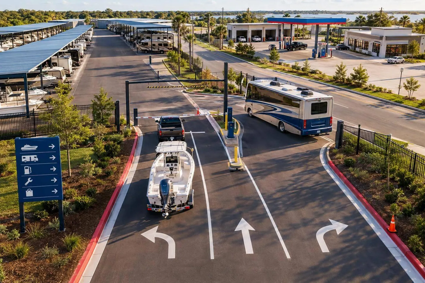
Measure the distance from the public road to the gate. Determine how many rigs can queue without blocking a travel lane, sidewalk, intersection, or neighboring driveway. Use reservations, historical entry records, event schedules, and occupancy to test arrivals during the busiest 15- or 30-minute period. Allow room for the largest expected rig.
Time gate opening and code entry. Verify keypad or app access, access hours, backup power, and emergency override. Can vehicles pull clear of the road before drivers operate the gate? Consider separate entry and exit lanes when limited width, simultaneous arrivals and departures, long queues, or poor visibility cause conflicts.
Owners should prioritize feasible fixes, such as lighting, traffic-control changes, access-control changes, restriping, or gate relocation. Buyers should verify that the entrance works as built and check legal access, easements, shared-driveway obligations, and approvals before assuming a fix is feasible.
Then test whether the same vehicle can reach fuel, dump, repair, and resupply stops without route problems.
Check Large-Vehicle Access to Fuel and Services
Nearby doesn't always mean usable. Field-check fuel, propane, dump stations, repair and towing services, wash facilities, and parts suppliers along the same routes customers use. Confirm entrance geometry, turning space, overhead clearance, pump- or service-lane length, and exits for the largest expected rig. Record actual drive times, forced U-turns, and detours - not just mileage.
Ask operators about hours, seasonal closures, payment limits, vehicle restrictions, maximum vehicle length, and trailer parking. Label each stop as usable, usable with restrictions, or not suitable, and document any limitation.
Owners should update customer resource guides with verified stops and flag service gaps. Buyers should keep a service-stop matrix showing which facilities, as built, can accommodate the expected rigs.
Rate Convenience and Keep Supporting Records
Once you’ve verified access, turning, and services, turn those findings into a 1–5 scorecard. Rate highway access, recreation routes, circulation, entrance visibility, queue capacity, nearby fueling and service access, compliance risk, and required improvements.
Define the scale before scoring: 5 means direct access with no material restrictions; 1 means unsafe geometry, unclear legal access, or a major route limit. Don’t let an average score outweigh a deal-breaking issue. Unresolved legal access, an unsafe intersection, inadequate emergency access, or an entrance the design vehicle can’t use should stand on its own.
Keep a dated file with maps, drive times, photos, measurements, vehicle specs, access rules, and repair estimates. For each material finding, record its likely effect on revenue, operating expenses, safety, approvals, and resale value. These details help owners plan repairs and buyers complete underwriting. Keep firm bids separate from rough allowances, and use the scorecard to distinguish fixable problems from limits that change the deal.
Separate Fixable Problems From Site Limits
Label each finding correctable, conditional, or structural. Minor lighting or striping repairs may be correctable. Moving a gate may depend on engineering and approvals, making it conditional. Inadequate frontage, tight approaches, and unsafe trailer intersections are structural limits.
Don’t stop at a proposed layout. Record the remedy, who’s responsible, estimated cost in U.S. dollars, approval status, schedule, and risk that would remain after the work.
Owners can use this record to put safety and access work ahead of cosmetic upgrades. Buyers can turn verified deficiencies into repair reserves or purchase-price adjustments while tracking unresolved risks separately. Missing approvals are unresolved diligence items - not confirmed construction costs. Put repairable issues in the improvement budget; structural limits may change whether the property is worth buying.
How far will customers drive for boat or RV storage?
Customers often travel 10 to 15 miles or more for boat and RV storage, compared with 1 to 5 miles for standard self-storage.
When evaluating a site, map its trade area around how your target customers travel - not a fixed radius. Use research and data to assess how rivers, highways, and railroads can limit or extend travel routes for large vehicles.
How can I estimate revenue lost to access problems?
Adjust revenue projections for stalls affected by tight turns, narrow aisles, or poor gate flow. Don’t assume every stall will earn full market rent. Account for lower occupancy, recurring rent concessions, or vehicle-size restrictions.
Use swept-path analysis, site-plan measurements, and feedback from on-site managers to identify stalls that are hard to lease without discounts. Compare these adjusted projections with full-market-rent projections to estimate lost revenue.
When should access issues stop me from buying a site?
Reconsider the deal or pass if your underwriting can’t account for access constraints, or if those constraints permanently limit your customer base. Check that large rigs can safely reach the site, pull fully off the public road before the gate, and enter reliably in bad weather.
Have a civil engineer run a swept-path analysis for the largest expected rig. Recurring maneuvering problems can hurt occupancy and long-term value, even when local demand is strong.